Extreme Heat Warning for New York City through the July 4th weekend | Live updates

An extreme heat warning is in effect through Saturday for much of the Tri-State area

WABC logo
Last updated: Friday, July 3, 2026 5:07PM GMT
ABC7 New York 24/7 Eyewitness News Stream

NEW YORK (WABC) -- New York City remains in the grip of a historic heat wave, with temperatures reaching 100 degrees on Thursday and tying a record high set in 1966. The dangerous stretch of heat will peak through Friday, when feels-like temperatures could soar as high as 115 degrees and a rare Level 4 of 4 Extreme Heat Risk remains in place.

The city is also dealing with poor air quality and little overnight relief. Temperatures tonight are expected to remain near 84 degrees, which would tie the warmest overnight low ever recorded in New York City.

While the heat begins to ease over the holiday weekend, it will still be very hot on July 4, with highs in the mid-90s. Scattered afternoon and evening thunderstorms could develop, potentially affecting outdoor celebrations and fireworks displays.

More widespread showers and thunderstorms are expected Sunday and Monday, helping temperatures trend lower. By Tuesday, highs may struggle to reach 80 degrees, with much more comfortable weather arriving by the middle of next week.

Residents are urged to stay hydrated, limit time outdoors during peak afternoon heat and watch for signs of heat-related illness. Checking on vulnerable neighbors and pets is also important during this prolonged stretch of dangerous weather.

Visit nyc.gov/beattheheat for more.

Stick with Eyewitness News for the latest forecast and weather alerts.


Key Headlines

Here's how the news is developing.
Phil Taitt Image
57 minutes ago

Mayor Mamdani shows of NYC's new cooling vans

New York City is set to reach some possible record-breaking high temperatures and a lot of people are looking for ways not to have a medical issue due to this dangerous heat.

One way that the city just rolled out this year is brand new cooling vans.

Mayor Zohran Mamdani gave Eyewitness News Reporter Phil Taitt an inside look at one of the vans to see how they work.

Phil Taitt has the latest.
ByKenton Gewecke ABCNews logo
12:40 PM GMT

New York City tied its hottest morning on record with low of 84

New York City tied its hottest morning on record, clocking a low temperature of only 84 Friday morning.

The last time this happened was July 22, 2011 - nearly 15 years ago.

There is a chance for showers and thunderstorms later Friday. If that happens over Central Park and the temperature drops below 84, this record will no longer be realized.

Thursday was the hottest afternoon temperature since 2012 (14 years) and Friday morning's low is the warmest since 2011 (15 years).

Friday afternoon, the high temperature for Central Park is forecast to reach 102. If that happens it will be the hottest temperature for NYC since July 22, 2011 - which was also the last time the low temp was 84.

In fact, July 22, 2011 temperatures reached a high of 104.

WABC logo
10:42 AM GMT

NJ Transit back on schedule for Friday morning commute

NJ Transit is on or close to schedule for the Friday morning commute. It's welcome news after a rough evening commute on Thursday.

Midtown Direct trains no longer diverted to Hoboken.

However, NJ Transit is warning of speed restrictions through Saturday due to the heat, to avoid damaging overhead wires and other equipment.

WABC logo
2:03 AM GMT

Extreme heat causes NJ Transit nightmare during rush hour

NJ Transit is asking its rail customers to find another way home if possible, cross-honoring on NJ Transit or private carrier buses, PATH, or even NY Waterway ferries, as electric trains are being slowed by the heat.

"What we want people to do is use all the methods we are making available...to try and use all of those systems to get home," NJ Transit President and CEO Kris Kolluri. "It's the most excessive temperatures we have had this year."

CeFaan Kim has the latest from Penn Station.

Sagging wires temporarily stopped two trains during the commute. In one instance, a rescue train was deployed to Harrison to get about 300 customers back to Hoboken Terminal. It took about 45 minutes to tow the disabled train back to Hoboken. During that time, the air conditioning was on, and police were distributing water on the train.

Meanwhile, the Hackensack Drawbridge, a century-old bridge that crosses the Hackensack River between Secaucus and East Rutherford, got stuck open for 25 minutes because of the heat, causing delays. NJ Transit decided not to open any more rail bridges for the rest of Thursday's commute as a result.

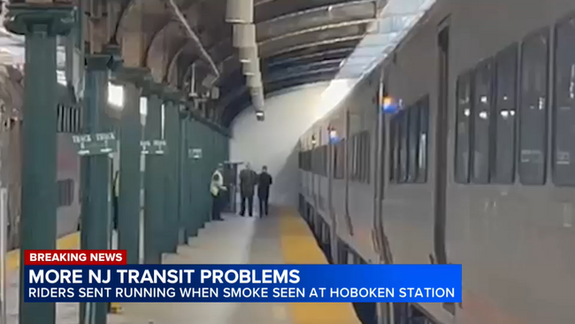
Amid the extreme temperatures, smoke was also seen at Hoboken station after 5 p.m. after the heat sparked a fire, sending some riders running from the platform. NewsCopter 7 was over the scene where smoke was seen on track 7.

Shannon Sohn has the latest from News Copter 7.

NJ Transit Latest Update

NJ TRANSIT rail service is subject to up to 60-minute delays and cancellations of select trains due to the impact on the equipment, related to the extreme temperatures. Midtown Direct service continues to be diverted to Hoboken. NJ TRANSIT rail tickets and passes are being cross honored on NJ TRANSIT and private carrier buses and PATH, at Newark Penn Station, Hoboken Terminal, and 33rd Street, New York and NY Waterway Ferry.

Customers should visit njtransit.com/ABC for available alternate service information.