Feb 21, 2026, 11:47 PM GMT
Explainer: What exactly is a blizzard?
A blizzard is bearing down on the New York metropolitan area, but how exactly do we define a blizzard?
Jeff Smith explains in the video below:
Stay with Eyewitness News for live updates on the storm. Check back here for frequent updates.


NEW YORK (WABC) -- The blizzard of 2026 impacted millions across New York City and the Tri-State area on February 22-23, 2026.
The major storm that blanketed the region with snow, canceled flights, disrupted transit and downed power lines.
More than 30 inches of snow fell on parts of Long Island and New Jersey.
What follows is our blog from coverage of the storm.
This blog is no longer being updated.
Please fill out the form below to submit weather photos and videos.
A blizzard is bearing down on the New York metropolitan area, but how exactly do we define a blizzard?
Jeff Smith explains in the video below:
Here is a breakdown of how the storm will impact your commute and how the MTA is preparing:
Subways and Buses: Going Local and Swapping Fleets
To accommodate snow-clearing operations, most New York City subway service will run local. The MTA has suspended all scheduled weekend track and infrastructure projects so crews can focus entirely on storm response.
While underground tracks are insulated from the weather, the MTA is deploying debris and de-icer trains to protect the 220 miles of exposed outdoor tracks. Lines particularly vulnerable to freezing precipitation include the A/S (Rockaway), N (Sea Beach), 7 (Flushing), B/Q (Brighton), and 5 (Dyre Ave).
Above ground, New York City Transit is making major changes to its bus fleet:
No Accordion Buses: All longer articulated buses are being pulled from service and replaced by 40-foot standard buses equipped with chained wheels.
Snow-Fighting Vehicles: 35 specialized snow-fighting vehicles are staged across the boroughs to clear terminals and high-traffic routes.
Route Curtailments: Bus service will be adjusted on a route-by-route basis depending on local road conditions.
Commuter Rails: Schedule Adjustments for LIRR and Metro-North
Commuter rail riders should expect shifting schedules as crews work to keep tracks and switches clear of ice. Both railroads are activating switch heaters and deploying trains equipped with special third-rail "shoes" to scrape away ice.
The LIRR will run a standard Sunday schedule on the morning of February 22, though evening modifications are possible on the Babylon, Port Washington, Huntington, West Hempstead, and Oyster Bay branches to allow for snow equipment deployment. Monday's service levels will be determined overnight based on storm severity. Note: Station waiting rooms will remain open 24/7 systemwide starting at 6:00 a.m. Sunday.
While Sunday will see a regular schedule, Monday will shift to an hourly service schedule, with branch lines operating on weekend schedules. Connecting services, including the Hudson Rail Link bus and the Haverstraw-Ossining Ferry shuttle buses, are suspended.
To prevent accidents and jackknifed vehicles, MTA Bridges and Tunnels is instituting a strict ban on empty tractor-trailers and tandem trucks from 7:00 p.m. Sunday through 10:00 a.m. Monday. The ban affects the Bronx-Whitestone, Cross-Bay, Henry Hudson, Marine Parkway, Robert F. Kennedy, Throgs Neck, and Verrazzano-Narrows bridges. Pedestrian walkways on several of these bridges may also close depending on wind and ice conditions.
For Access-A-Ride users, 24/7 paratransit service will continue, though customers are advised to expect delays. Drivers have been instructed to follow severe weather protocols and exercise extra patience before declaring a customer a "no-show."
How to Stay Informed
With conditions expected to evolve rapidly, the MTA strongly encourages all riders to check for real-time updates before heading out. Customers can check transit statuses via:
The MTA app or TrainTime app (available on Apple and Google Play)
The MTA's official website at mta.info
Phone by dialing 511
With a historic blizzard approaching Long Island, Nassau County Executive Bruce Blakeman on Saturday announced that all nonessential vehicles should be off public roads and highways from 9 p.m. Sunday night until 9 a.m. Monday morning.
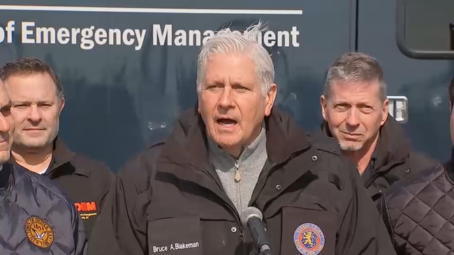
"This is a major blizzard that will bring major accumulations and dangerous conditions," he said.
"Essential vehicles shall include all emergency vehicles, as well as those operated by municipal workers, doctors, nurses, hospital workers, and other essential personnel. All other vehicles are banned from operating on public roadways," he said.
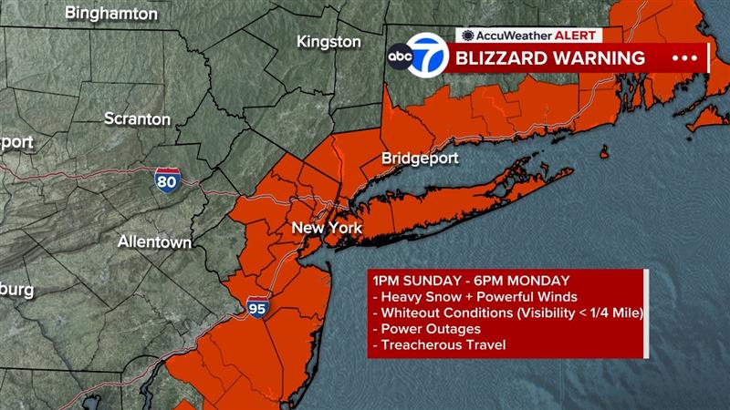
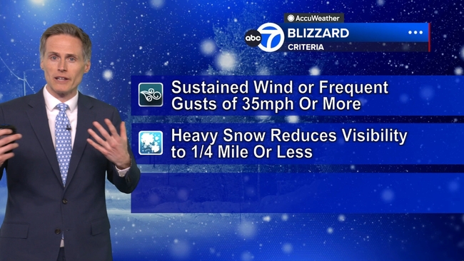
Blizzard Warnings are in effect for Long Island, all five boroughs of New York City, Westchester and Rockland counties, and coastal Connecticut along with most of New Jersey.
A Blizzard Warning means winds or gusts will hit or exceed 35 mph along with blowing snow, with visibility knocked down to 1/4 mile or less for three hours or more.
The worst of the storm arrives late Sunday afternoon and lasts through sunrise Monday. Snowfall rates could reach 2-3 inches per hour, with strong winds creating whiteout conditions - especially along the coast. The storm's central pressure off the coast will rival that of a category 2 or 3 hurricane. This strengthening will collapse in colder air and change all precipitation to heavy snow.