2 hours and 29 minutes ago
NYC, most of Tri-State under Flood Watch for Tuesday

Last updated: Tuesday, July 28, 2026 3:01PM GMT

NEW YORK (WABC) -- A Flood Watch is in effect for New York City and much of the Tri-State area as powerful storms are poised to hit the region starting Tuesday afternoon with significant rainfall and the potential for flash flooding.
The danger for disruption during this long-duration event is notable, with rain starting in the early afternoon, threatening the evening commute and continuing into the late evening.
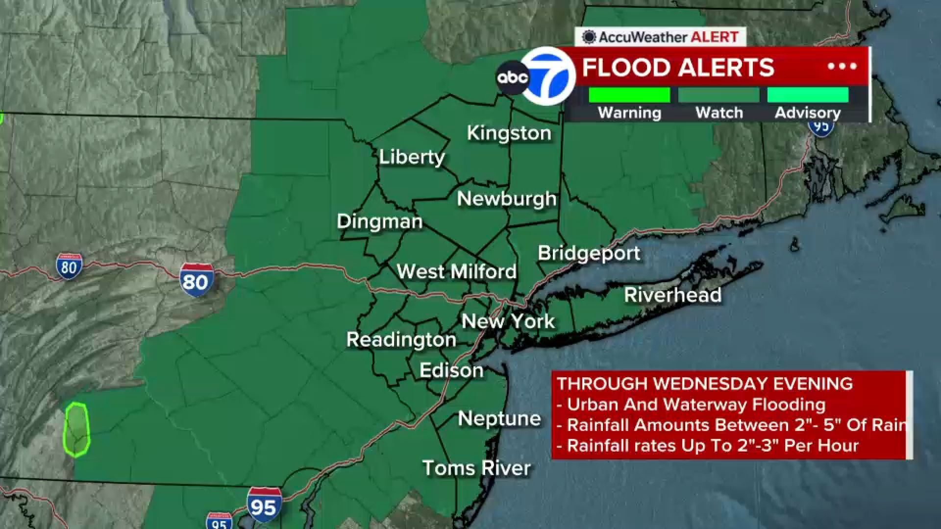
Parts of the area could contend with rainfall rates of 2 to 3 inches per hour, with rainfall totals on average of 2 to 5 inches. Some isolated areas could see even more rain, especially north and east of the city.
The key areas where the flood threat is greatest are northern New Jersey, New York City and the Hudson Valley, where there is a level 3 out of 4 risk for flash flooding.
The Flood Watch will continue through Wednesday morning. The coverage area includes the Bronx, Brooklyn, Manhattan, Queens, and Staten Island.
Outside of New York City, Nassau County, Westchester County, Orange County, Putnam County, Rockland County are under the watch.
In New Jersey, the areas are Bergen County, Hudson County, Essex County, Passaic County and Union County.
In Connecticut, Fairfield and New Haven counties are under the watch.
On Wednesday, the rain continues but it will be more scattered and will favor areas east of the city.
Join Eyewitness News starting at 4 a.m. Wednesday for live coverage of the storms. Watch on TV or right here.
2 hours and 31 minutes ago
AccuWeather Alert: Flooding downpours expected later today
An AccuWeather Alert is in effect as a dangerous setup could bring hours of flooding downpours to the Tri-State later today into Wednesday morning. Some areas could see 2 to 5 inches of rain, with locally higher amounts and rainfall rates of up to 2 to 3 inches per hour. If you encounter a flooded roadway, turn around, don't drown.
3 hours and 24 minutes ago
Airlines cancel flights ahead of Tuesday's storms
Airlines starting the day with cancellations on Tuesday, anticipating storms that will disrupt their schedules.
So far:
Kennedy: 117 flights cancelled, 17% of schedule
LaGuardia: 109 flights cancelled, 20% of schedule
Newark: 61 flights cancelled, 10% of schedule
9:49 AM GMT
Dozens rescued after flash flooding, hail and lightning slam parts of New Jersey
Communities across New Jersey are dealing with the aftermath of Monday night's powerful storms, which brought heavy rain, flash flooding, lightning and hail.
In Hawthorne, the fire department responded to more than 20 calls for service, including 17 water rescues, after floodwaters submerged portions of Route 208. At least five people were also rescued from stranded vehicles in River Edge.
In Ridgewood, officials said lightning struck a building, blowing out an electric meter and sparking a two-alarm fire. Hail was also reported in Franklin Lakes and Edison.
While the heaviest rain has moved out, additional showers and thunderstorms are expected Tuesday afternoon and evening. Forecasters warn another round of heavy downpours could lead to localized flooding, so drivers are urged to avoid flooded roadways.