Severe storms trigger flash flooding, possible tornadoes across Tri-State | Live updates

WABC logo
Last updated: Wednesday, July 22, 2026 2:50PM GMT
ABC7 New York 24/7 Eyewitness News Stream
Stream New York's #1 news - AccuWeather - original content 24/7

NEW YORK (WABC) -- Rounds of severe storms triggered downpours, flash flooding, damaging winds and possible tornadoes on Tuesday, just days after storms walloped New York City and the Tri-State area over the weekend.

The second dose of dangerous storms led to tornado warnings and watches being issued by the National Weather Service, which have since expired as the severe weather conditions move offshore.

RELATED | Watches, warnings and advisories from the National Weather Service

Parts of New Jersey were particularly hard-hit by Tuesday's storms, including Stanhope, where a possible tornado was spotted.

A video posted on social media also showed a funnel cloud on the ground at a golf center in Parsippany, about one mile north of the Troy Hills area.

NWS will survey those two locations on Wednesday for possible tornadoes.

And while some afternoon storms on Wednesday won't be as severe, the NWS has put New York City and much of the Tri-State area at a marginal risk (1 out of 5) for for severe thunderstorms with the primary threat being damaging winds.

Stay with ABC 7 and Eyewitness News for the latest updates.

Key Headlines

Here's how the news is developing.
Sonia Rincón Image
Jul 21, 2026, 8:08 AM GMT

Residents in flood-prone areas of Queens concerned with next round of storms

There's concern that parts of New York City could see the same kind of flash flooding that the area saw this weekend, especially residents in one part of Flushing, Queens.

They say the flooding is so common that they no longer buy nice things. Things that once surrounded them in their living rooms and bedrooms are being crushed up and carted away.

All the first floors of the homes along 153rd Street and Peck Avenue flooded, again, Saturday morning as sewage drains backed up in a deluge of rain.

The New York City Emergency Management commissioner visited the area Saturday afternoon, and Eyewitness News reported from there Saturday night after the flash flood receded. But a mess that happens in a flash can take days to get rid of.

Eyewitness News reporter Sonia Rincon spoke with residents about how they are preparing for the next round of storms.
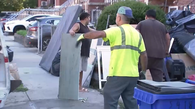
Sonia Rincon spoke to residents in Flushing, Queens about how they are preparing for Tuesday's storms.
WABC logo
Jul 21, 2026, 9:02 AM GMT

Potential rainfall totals for Tri-State area

Meteorologist Lee Goldberg breaks down the potential rainfall totals the Tri-State area could get from Tuesday's storms.

Lee Goldberg breaks down another round of severe thunderstorms that could have a similar impact as storms this past weekend.
Jul 21, 2026, 8:08 AM GMT

NYCEM activates city's Flash Flood Emergency Plan

NYCEM has activated the city's Flash Flood Emergency Plan.

This proactive approach includes targeted inspection and clearing of catch basins in flood-prone areas by the agencies like the Department of Environmental Protection and the Department of Transportation to help reduce street flooding before heavy rain begins.

New Yorkers should allow extra travel time during periods of thunderstorms and heavy rain. Do not remain in or return to areas or buildings that are flooding.

Jul 21, 2026, 8:08 AM GMT

DOB tells contractors and property owners to prepare for severe weather

The DOB is reminding all builders, contractors, crane operators, and property owners to secure their construction sites, buildings, and equipment.

Parts of New York City could experience heavy rain and wind gusts up to 70 mph.

The department will be performing random spot-check inspections of construction sites around the city. If sites are not secured, the department will take immediate enforcement action - issuing violations and Stop Work Orders, where necessary.

Winds may reach higher speeds and last longer than forecast in certain areas of the city.