Severe storms impacting July 4th fireworks, festivities on final day of extreme heat

An extreme heat warning is in effect through Saturday for much of the Tri-State area

WABC logo
Last updated: Sunday, July 5, 2026 1:08AM GMT
ABC7 New York 24/7 Eyewitness News Stream

NEW YORK (WABC) -- Strong evening thunderstorms could wreak havoc on July 4th fireworks celebrations across the Tri-State area on the final day of a dangerous heat wave.

A Severe Thunderstorm Warning has been issued for portions New York City, the Hudson Valley, and northern New Jersey. A Severe Thunderstorm Watch is also in effect for New York City, New Jersey and portions of the Hudson Valley. Any storm has the potential to produce damaging winds, downpours and even some hail.

The timing of the storms could coincide just as fireworks kick off across the region, including New York City, which could see storms move in during the 9 p.m. and 10 p.m. hour.

The Macy's Fourth July Fireworks start time was moved up from 9:25 p.m. 9:02 p.m. as a result of the incoming storms.

The silver lining is that the storms will finally break the four-day heat wave, as temperatures fall back into the 80s on Sunday with a chance for showers developing later in the day.

More widespread showers and thunderstorms are expected Sunday night into Monday, bringing the most significant relief from the oppressive heat and humidity.

Anyone heading outdoors for holiday festivities should stay hydrated, monitor air quality conditions, and keep an eye on the weather later Saturday as storms may become heavy and dangerous in some locations.

Stick with Eyewitness News for the latest forecast and weather alerts.

Key Headlines

Here's how the news is developing.
ByEyewitness News WABC logo
Jul 04, 2026, 10:38 AM GMT

NJ Transit delays continue Saturday morning after severe storms damage rail lines

NJ Transit riders are continuing to experience major service disruptions Saturday morning as crews work to repair infrastructure damaged by severe storms that swept through the state Friday night.

According to NJ Transit, service remains suspended on the Morris & Essex Line, Gladstone Branch, Raritan Valley Line and North Jersey Coast Line due to storm-related damage.

Officials said repair crews remain on scene assessing and repairing damaged infrastructure. The Morris & Essex Line and North Jersey Coast Line are expected to remain suspended through Saturday morning while repairs continue.

Service has resumed on the Main, Bergen County, Port Jervis, Pascack Valley and Hoboken lines, though riders should expect residual delays.

Meanwhile, Northeast Corridor Line service is operating on or close to schedule after an earlier disabled train near Metuchen. NJ Transit said trains may still experience residual delays of up to 30 minutes in both directions. Eastbound trains are no longer using track-level boarding at New Brunswick, Edison and Metuchen.

NJ Transit is honoring rail tickets and passes on NJ Transit and private carrier buses, as well as PATH service at Newark Penn Station, Hoboken Terminal and 33rd Street in New York.

Customers are encouraged to check NJ Transit for the latest service updates and alternate travel options before heading out.
WABC logo
Jul 04, 2026, 2:59 AM GMT

NJ Transit train service severely disrupted due to damage from strong storms

Several NJ Transit train lines have been suspended or delayed due to damage from severe storms that moved through the state on Friday night.

Latest updates on train, rail service:

Due to damage from the severe storms that went through the state, train service is suspended on Morris and Essex, Gladstone Branch, Raritan Valley, and North Jersey Coast Lines. Crews have been deployed to assess and repair damage to the infrastructure. Service has resumed on Main, Bergen County, Port Jervis, Pascack Valley lines and Hoboken with residual delays. NJ TRANSIT rail tickets and passes are being cross honored on NJ TRANSIT and private carrier buses and PATH at Newark Penn Station, Hoboken Terminal, and 33rd Street, New York. Customers should visit http://njtransit.com/ABC for available alternate service information.

River Line service is suspended in both directions between Roebling and Cass Street Stations due to weather-related downed trees on the tracks near Roebling Station. Substitute bus service is being provided.

Northeast Corridor Line rail service is subject to up to 1-hour delays in both directions due to a disabled train near Metuchen. Eastbound trains are track-level boarding and deboarding at New Brunswick, Edison, and Metuchen. Stair use is required to access trains. Customers unable to use stairs should follow crew instructions or use stations with accessible services. Customers should visit njtransit.com/ABC for available alternate service information.

WABC logo
Jul 04, 2026, 12:47 AM GMT

NJ Gov. Sherrill warns residents of severe weather, dangerous travel conditions

WABC logo
Jul 04, 2026, 1:08 AM GMT

Extremely dangerous storms hit NYC, NJ

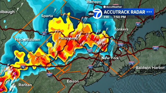
Extremely dangerous storms with 70-80 mph wind gusts raced from northern New Jersey into the New York City area on Friday night.

Jeff Smith has an update on an AccuWeather Alert for extremely dangerous storms with 70-80mph wind gusts racing from northern New Jersey into the New York City area.

There are already many reports of damage coming in from northern New Jersey.