Jul 18, 2026, 7:46 PM GMT
Severe Thunderstorm Warning for parts of New Jersey
Severe Thunderstorm Warning for portions of Middlesex, Monmouth, and Ocean Counties as storms could contain 70mph wind gusts.


NEW YORK (WABC) -- Storm cleanup is the focus on Sunday after severe thunderstorms battered New York City and parts of the Tri-State area with a dangerous combination of flash flooding and gusty winds.
Heavy rain on Saturday turned streets in SoHo into a river, while flood waters left drivers stranded along busy highways. In Woodside, Queens, firefighters drove through the flooded waters to rescue trapped drivers on the BQE, and in Flushing, homeowners were left cleaning out their homes after flood waters caused extensive damage.
Sunday will look much different -- with sunshine and less humidity, and better air quality overall after rain and storms cleansed the atmosphere of the noxious Canadian wildfire smoke. There will still be enough particulate matter in the air to be a problem for sensitive groups.
However, after Saturday's wicked storms, areas hard-hit by flooding will focus on cleanup, as the city's aging infrastructure once again endured another test.
Eyewitness News and ABC 7 for the latest.
Severe Thunderstorm Warning for portions of Middlesex, Monmouth, and Ocean Counties as storms could contain 70mph wind gusts.
Northeast Corridor and North Jersey Coast Line westbound rail service had to bypass the EWR station due to flooding conditions.
Eastbound customers are advised to transfer at Elizabeth station for eastbound service to EWR.
More than 1,000 flights have been cancelled and over 4,000 delayed due to weather across the Northeast. According to the FAA, thunderstorms impacting the New York and Philadelphia metropolitan areas have resulted in ground stops at major airports throughout the region.
Airports currently under a ground stop due to thunderstorms include, BOS, EWR, LGA, JFK, PHL, DCA, IAD and BWI.
Most impacted airports:
-LGA: 264 cancellations- flights out of airport seeing delays of about 4 hours
-JFK: 242 cancellations- flights out of airport seeing delays of about 2 hours
-EWR: 153 cancellations- flights out of airport seeing delays of about 3 hours
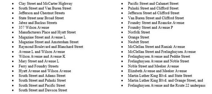
Drivers in Newark are asked to avoid the following locations due to the potential for flooding: