Dec 26, 2025, 3:15 PM GMT
Live
NYC area digs out from biggest snowstorm in years with cold night ahead | Live updates
Central Park saw 4.3 inches of snow, within the forecast range of 4 to 8 inches. But ice suppressed totals across many areas.

Last updated: Sunday, December 28, 2025 3:40AM GMT

NEW YORK (WABC) -- The most significant winter storm to hit the Tri-State area in almost four years ended on Saturday, with the heaviest snowfall north and east of New York City.
With the storm a memory, the concern now shifts to slick, icy roads and sidewalks, as temperatures will stay below freezing through early Sunday. A Winter Weather Advisory has been put into effect for ice north and west of New York City.
"Motorists and pedestrians should use caution. Reduce speed, allow extra time, and be prepared for areas of slippery travel Saturday evening through midday Sunday," the weather service said.
The snowstorm was notable for Central Park, which recorded 4.3 inches of snow, the highest amount in the park since the storm of Jan. 28-29, 2022, which dropped over 8 inches.
Higher totals were kept down in New Jersey due to ice; some areas of the Hudson Valley, Long Island, and Connecticut, however, saw more substantial snowfall.
With the storm a memory, the concern now shifts to slick, icy roads, as temperatures will stay below freezing through early Sunday
Some of the more impressive numbers were in Connecticut, where the expected heavier snow bands set in. New Fairfield came in with 9.1 inches, Fairfield with 7 inches, Bridgeport at 7.1, and Newtown with 6 inches.
Parts of Long Island saw over half a foot, with Babylon and Orient both recording 7.5 inches, Mattituck coming in at 7 inches, North Patchogue getting 6.8 inches, 6.6 coming down at Islip, and Hampton Bays reporting 6.5.
The Hudson Valley was also in the snow sweet spot, with Lake Carmel at 6.5 inches, Armonk at 6.4 inches, Peekskill at 6.1 inches and Port Chester at 5.9.
The intrusion of sleet reduced totals in other areas more than expected, holding down numbers in New York City and points south and west. New York City numbers included 4.3 inches in Fordham in the Bronx, and LaGuardia and JFK both came in at 4.1 inches. The story was the same in New Jersey, with lower amounts, including 4 inches in Harrison, 3 inches in Springfield and 2.5 inches in Newark.
The worst of the storm began Friday evening, but by dawn, lingering light snow was tapering off and most storm warnings had expired except in areas north and west where slick travel was a concern because of snowy and icy roads.
RELATED | Click here for the latest AccuWeather forecast
Click here for the latest advisories, watches and warnings from the National Weather Service
The storm was an Alberta Clipper that had been infused with energy from the Pacific storms delivering an atmospheric river of rain to the West Coast. As this system crashed into the cold air in our area, it squeezed out a lot of snow in a hurry for parts of the region. Meteorologist Jeff Smith described the system as an "Alberta Clipper on steroids."
Sunday will be ice cold, then clouds will roll in. The daylight hours will be dry, but some freezing rain will move in Sunday evening, especially north and west, which could create another travel issue. Monday will bring a brief warmup before temperatures plummet again for the remainder of the week.
RELATED | Click here for the latest advisories, watches and warnings from the National Weather Service
Key Headlines
- Dec 27, 2025, 2:10 AM GMT
- Dec 26, 2025, 9:31 PM GMT
- Dec 26, 2025, 9:28 PM GMT
- Dec 26, 2025, 10:28 PM GMT
- Dec 26, 2025, 3:15 PM GMT
Here's how the news is developing.
Dec 26, 2025, 3:44 PM GMT
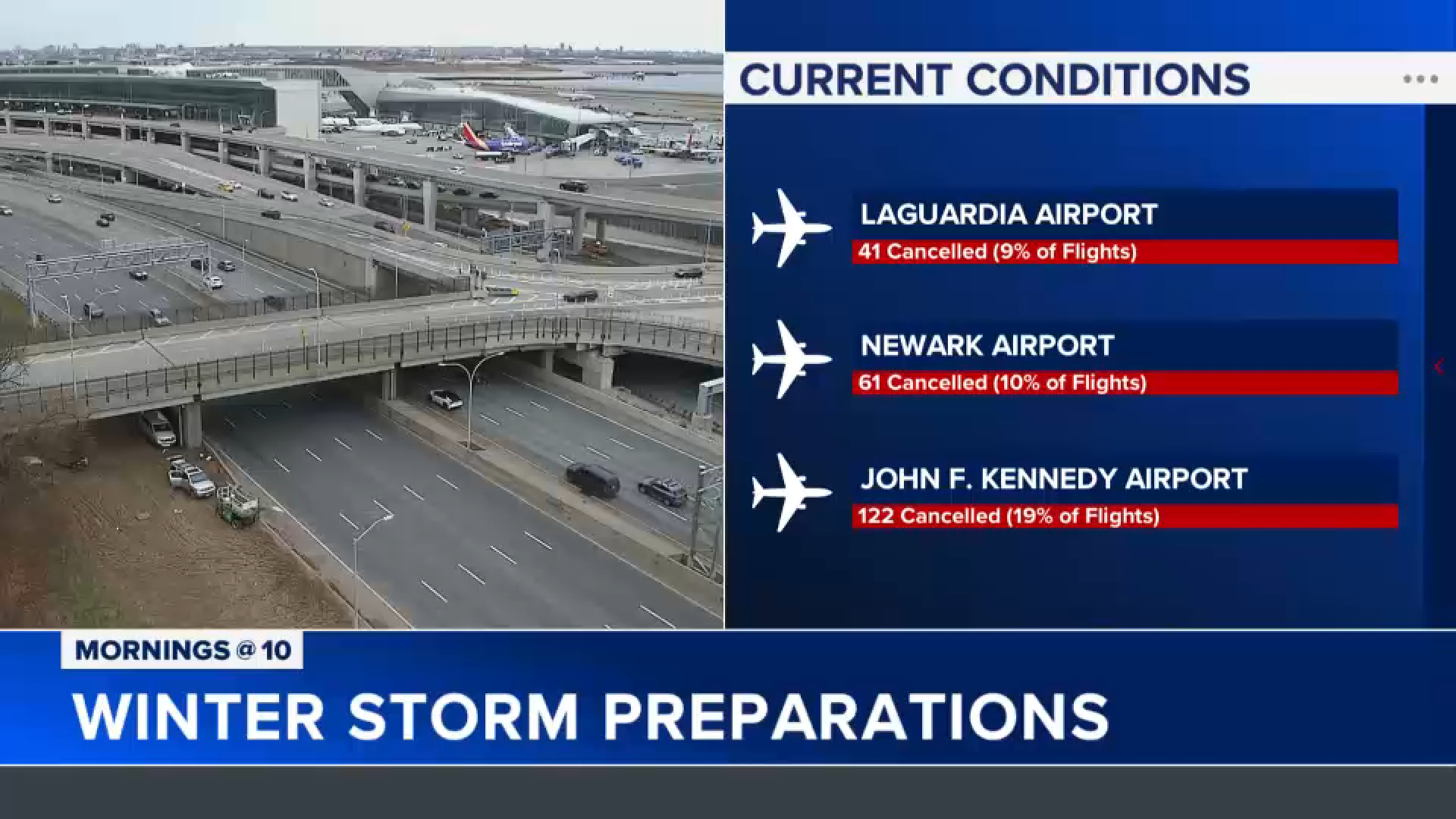
Area flight cancellations as of 9 a.m.
There are already flight cancellations at all three area airports, likely indicating the airlines are getting ahead of tonight's inclement weather.
Jet Blue is the national leader for flight cancellations, with 219 flights cancelled, 22% of their flight schedule. Jet Blue has significant operations at all three area airports. Delta is second with 161 flights cancelled, 5% of their schedule.
JFK -- 122 cancelled (19% of flights)
Newark -- 61 cancelled (10% of flights)
LaGuardia -- 41 cancelled (9% of flights)
Dec 26, 2025, 3:15 PM GMT
Tri-State prepares for impact
New York City Emergency Management has issued a travel advisory for tonight into tomorrow.
New York State is ready to deploy more than 1,600 large plow trucks as needed, and the State Department of Transportation is prepared to respond.
This week marks a peak travel period amid the rush of the holiday season.
The Port Authority of New York and New Jersey said that it was expecting nearly 15 million travelers to use major local airports like JFK, Newark and LaGuardia -- along with its bridges and tunnels during the holiday season, with travel peaking on Sunday.
City officials are now urging people to stay off the roads and adjust travel plans.
Jaysha Patel has more: