Winter storm pulls away after dumping heavy snow; frigid air won't budge | Live updates

The storm left well over a foot of snow in parts of the area, and cold air will be locked in place into early February.

WABC logo
Last updated: Tuesday, January 27, 2026 4:38PM GMT
ABC7 New York 24/7 Eyewitness News Stream

NEW YORK (WABC) -- The winter storm of January 2026 that once covered 2,000 miles across the nation has pulled away, leaving New York City and the Tri-State area to dig out from the biggest snowfall in years.

The big dig coincided with the start of the work week, with motorists faced with treacherous drives and commuters on public transit that contended with challenges, too, though subway service was largely normal.

The storm left almost a foot and half of snow in parts of the region, while Central Park came in at 11.4 inches, a record for the day. These were not the final numbers and could go up.

There were a few more scattered snow showers early Monday but the bulk of the storm has headed out to sea. Monday's notable weather feature was the bone-chilling cold, and it will linger through at least the next seven days. Temperatures are not expected to top the freezing mark until Feb. 3, when a high of 33 is expected, still well below normal.

That means the snow and ice will stick around at least into early February.

Latest Forecast

Stay with Eyewitness News for live updates on the commute and the recovery from the storm. Check back here for frequent updates.

Click here for the latest advisories, watches and warnings from the National Weather Service


Key Headlines

Here's how the news is developing.
Jan 23, 2026, 1:52 AM GMT

Weekend winter storm forecast: Much of nation facing snow and ice in sprawling storm

What is shaping up to be one of the biggest winter storms in years was incubating off the West Coast Thursday ahead of its steady march across the nation, threatening to deliver heavy snow and crippling ice to dozens of Southern states before curving north toward the New York City area for a day of potentially heavy snow on Sunday.

The storm, with a potential historic sweep unlike any seen in recent years, will reach the doorstep of the Tri-State Sunday morning.

A Winter Storm Watch has been issued for the Tri-State area from late Saturday night through Monday afternoon, in addition to a Cold Weather Advisory that goes into effect Friday night.

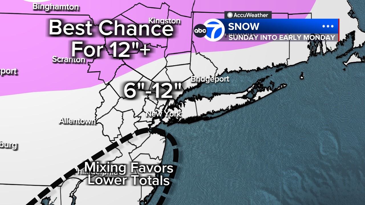
Areas well north and west of New York City could see accumulations of a foot or more of snow, with bullseye regions including extreme northwestern New Jersey, the Hudson Valley and eastern Pennsylvania.

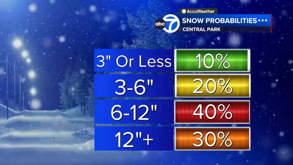
New York City and Long Island, as well as much of New Jersey, could land in the 6-to-12-inch range, but those numbers could be tamped down by mixing of freezing rain and sleet, likely along the immediate coast later in the day.

Regardless of final totals, travel is likely to be difficult, and utilities will be on high alert for outages.

On Thursday, the New York region enjoyed a brief thaw, with temperatures soaring into the 40s. That easing of the Arctic grip won't last long, as extremely cold air floods back on Friday and locks in for days to come.

That cold air will be spilling across much of the nation, setting the stage for the vast winter storm.

The storm that will sweep the country is hatching off the California coast before marching across the nation, where it will crash into cold air and a disturbance from Canada to create potentially dangerous conditions, especially in parts of the country that are not familiar with extreme winter weather.

The storm is picking up Pacific Ocean moisture, and hurricane hunters have entered the system to get an early feel for the storm's dynamics.

As the storm gets itself together, it will drop ice and snow from Texas through the deep South and then curve toward the Mid-Atlantic and the Northeast.

Lee Goldberg has the AccuWeather forecast.

Winter weather alerts begin as far west as New Mexico and currently stretch as far east as the Carolinas and north toward New England.

Areas in North Texas, Oklahoma into Arkansas, part of Mississippi, and Tennessee could be dealing with significant ice, with snow to the north, on Saturday as it heads toward the Southeast.

Icing is one of the biggest concerns wherever it sets up. A half an inch of ice adds hundred of pounds of tension to powerlines.

In our area, the storm will initially battle some dry damming from the Arctic air at first but will eventually overcome it as snow overspreads the Northeast.

Governmental agencies across the Tri-state area are taking the threat seriously and are preparing for a significant snow storm.

The high on Saturday will be 18 with a low of just 12, and wind chills will be below zero. While Saturday will be brutally cold, it will be dry, making it a good day to take care of any last-minute preparations ahead of the storm.

Check back regularly for an updated forecast discussion.

AP logo
Jan 21, 2026, 9:42 PM GMT

An expected major winter storm already has some leagues reshuffling games this week

One year after a winter storm forced postponements across U.S. sports, another major weather system is prompting a reshuffling of games this week and threatened to wreak havoc on the weekend schedule.

A storm that meteorologists say could rival the damage of a major hurricane is expected to bring snow, ice and frigid temperatures from New Mexico to New England starting Friday.

Major League Baseball's Texas Rangers canceled their annual Fan Fest event scheduled for Saturday due to the weather forecast for frozen precipitation in North Texas and "in the interest of safety for players, fans, and employees."

The Sun Belt Conference preemptively shook up its women's basketball schedule, moving around the start times on several games from Thursday through Saturday. The American Athletic Conference also adjusted its weekend men's and women's basketball schedules, moving some games up to Friday.

Tennessee's swim meet at Georgia and the USC Upstate women's basketball game at Longwood were moved up to Friday from Saturday due to the forecast.

Jan 21, 2026, 9:53 PM GMT

Early call for snow probability

Here is an early call for snow probabilities:

WABC logo
Jan 21, 2026, 9:31 PM GMT

Some New Jersey towns face salt shortage ahead of weekend snow storm

You're not alone if you're looking for salt for the upcoming storm and can't find any. Stores across the region are out, or on their last few bags.

West Milford Hardware and Supply tried to order two pallets of salt normally used for water softeners.

Two pallets were ordered, but only one was delivered.

Several municipalities are also finding it difficult to get their hands on enough salt for the upcoming storm, like Piscataway.

"We have about 500 roadway miles in our community, but we're down to under 500 tons which is basically only going to take care of intersections," said Piscataway Mayor Brian Wahler.

He says because supplies are so low, municipalities are on the bottom of the list for deliveries.

Toni Yates reports on the salt shortage in New Jersey.