Winter storm pulls away after dumping heavy snow; frigid air won't budge | Live updates

The storm left well over a foot of snow in parts of the area, and cold air will be locked in place into early February.

WABC logo
Last updated: Tuesday, January 27, 2026 4:38PM GMT
ABC7 New York 24/7 Eyewitness News Stream

NEW YORK (WABC) -- The winter storm of January 2026 that once covered 2,000 miles across the nation has pulled away, leaving New York City and the Tri-State area to dig out from the biggest snowfall in years.

The big dig coincided with the start of the work week, with motorists faced with treacherous drives and commuters on public transit that contended with challenges, too, though subway service was largely normal.

The storm left almost a foot and half of snow in parts of the region, while Central Park came in at 11.4 inches, a record for the day. These were not the final numbers and could go up.

There were a few more scattered snow showers early Monday but the bulk of the storm has headed out to sea. Monday's notable weather feature was the bone-chilling cold, and it will linger through at least the next seven days. Temperatures are not expected to top the freezing mark until Feb. 3, when a high of 33 is expected, still well below normal.

That means the snow and ice will stick around at least into early February.

Latest Forecast

Stay with Eyewitness News for live updates on the commute and the recovery from the storm. Check back here for frequent updates.

Click here for the latest advisories, watches and warnings from the National Weather Service


Key Headlines

Here's how the news is developing.
Jan 24, 2026, 12:34 AM GMT

Winter storm forecast: Up to 18 inches of snow could hit parts of Tri-State area amid deep freeze

The stage is set for one of the most significant winter storms to hit the United States in years, with two-thirds of the nation in the path of a monstrous system that will deliver snow and ice amid punishing polar cold, with the immediate New York City area likely to get as much as a foot of snow on Sunday, with up to 18 inches inland.

At least 17 states have declared states of emergency so far, including New York and New Jersey, and thousands of flights have already been canceled. Over 180 million people are in the path of this storm. Heavy ice could pose serious risks to power and communication grids as well as roads and transportation systems from the Southwest to the Northeast amid Arctic-cold temperatures.

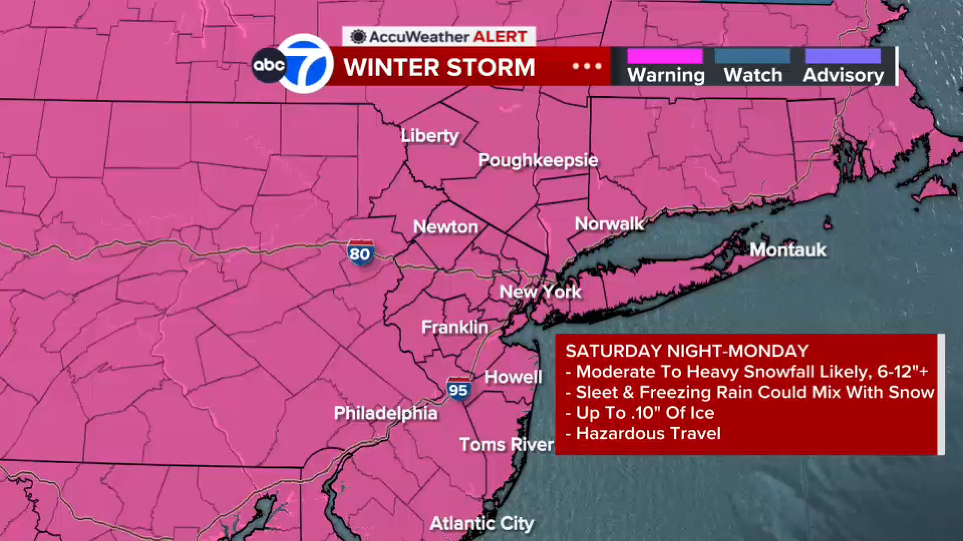
A Winter Storm Warning has been issued for New York City and the Tri-State area from early Sunday morning to Monday night, in addition to a Cold Weather Advisory that goes into effect Friday night.

Click here for the latest advisories, watches and warnings from the National Weather Service

In New York, residents will wake up to subzero wind chills on Saturday, the final day to prepare for the storm, and once the system clears out Monday, the Arctic grip will not relent all week, meaning all that snow and ice will not melt away anytime soon, a rare phenomenon in recent years.

The storm is the result of disturbances coming from the west colliding with Arctic cold, forming a sprawling system that will move from New Mexico and the Texas panhandle Friday night with snow and ice and then extend its wintry march east across dozens of Southern states before reaching the Mid-Atlantic and curving north.

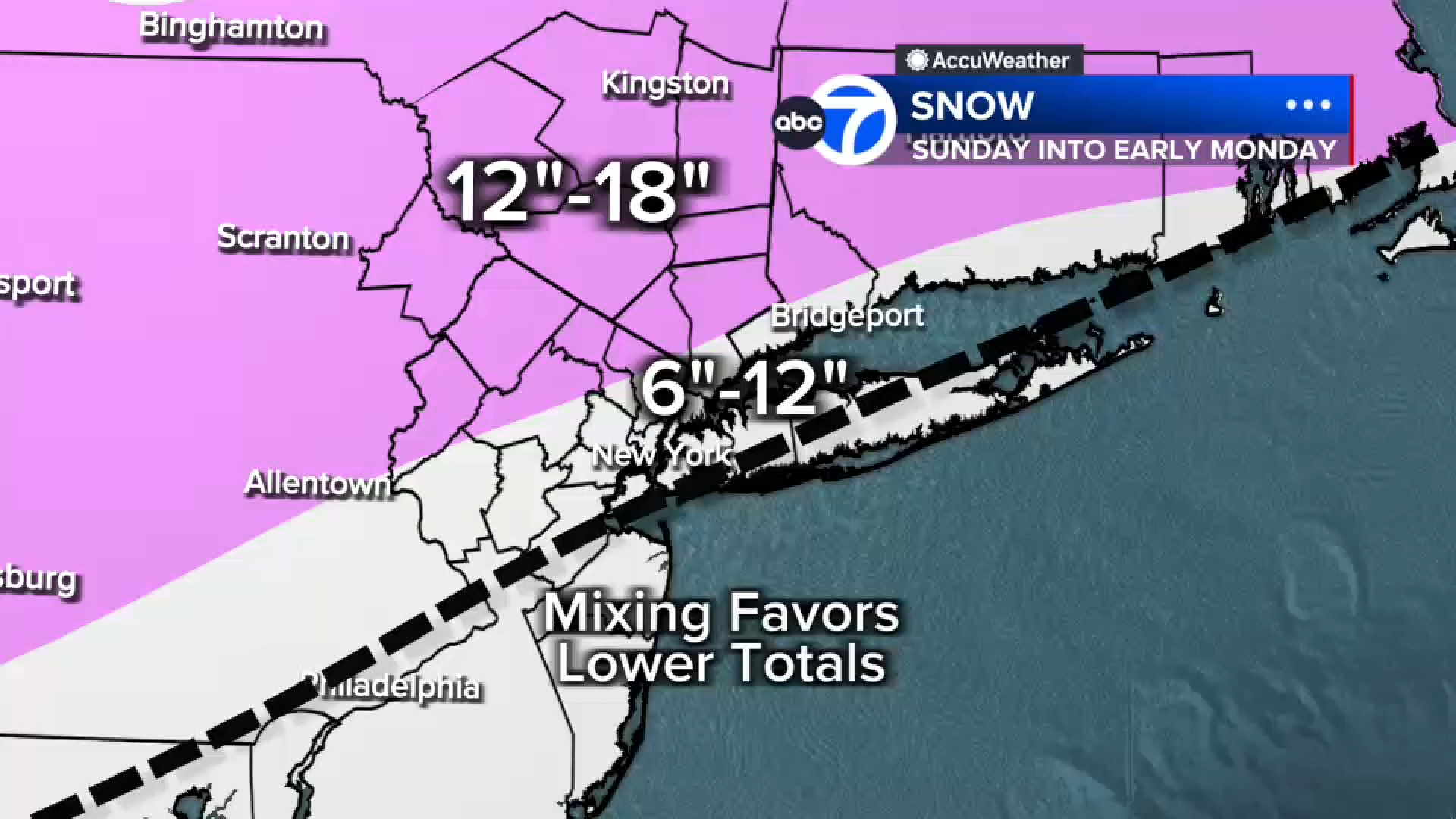
After initially fighting the dry, cold air mass, the snowfall will begin in earnest Sunday morning, likely around dawn, in New York City and the Tri-State area, with rapid accumulations from snowfall rates that could reach 1 to 2 inches per hour accompanied by whiteout conditions. Well north and west of New York City, the snow will pile up unimpeded until early morning Monday, when it will finally taper, leaving 12 to 18 inches.

In and around New York City, including parts of New Jersey and Long Island, expect 8 to 12 inches, and mixing later in the day could hold down totals. Even so, toward the of the event, it could go back to snow.

We introduced a 4 to 8 inch zone for southeastern Monmouth County, most of Ocean County, and the south shore of Long Island. These areas will likely mix in sleet earlier, cutting down on higher totals.

Even though temperatures will only reach 22 in the city on Sunday, well below freezing, the mixed precipitation will result from the intrusion of warmer air higher in the atmosphere, converting the snow to a wintry mix.

Regardless of final totals, travel is likely to be difficult if not impossible in places, and utilities will be on high alert for outages. Digging out from so much snow and ice, already burdensome, will be complicated by the longest stretch in eight years of temperatures staying below freezing for an extended period.

Governmental agencies across the Tri-state area are taking the threat seriously and are preparing for a significant snow storm.

While Saturday will be brutally cold, it will be dry, making it a good day to take care of any last-minute preparations ahead of the storm.

Check back regularly for an updated forecast discussion.

WABC logo
Jan 23, 2026, 2:26 PM GMT

Gov. Hochul declares State of Emergency for New York

Gov. Kathy Hochul declared a State of Emergency for New York during a storm briefing on Friday morning.

The governor said all state employees will be working from home on Monday.

She said her State of Emergency will also allow the state to plow the streets of New York City.

Hochul said she spoke to Mayor Zohran Mamdani on Friday morning ahead of his own storm briefing.

"I let him know we have a governor from Buffalo. If he wants any tips, I will give him some of them, and he is ready to go," Hochul said.

WABC logo
Jan 23, 2026, 3:43 PM GMT

NYC students to bring virtual learning equipment home on Friday

New York Mayor Zohran Mamdani joined city officials, including Schools Chancellor Kamar Samuels, for a 9:30 a.m. weather briefing at the city's Emergency Management headquarters in Downtown Brooklyn.

They announced schools will either be in session in-person on Monday or remote learning.

There will not be a traditional snow day, Mayor Mamdani said.

There will be no traditional snow day for New York City Public School students, Mayor Mamdani says, but the decision on in-person learning or remote has yet to be decided.

Mamdani promised to make the decision on whether schools will be open by noon Sunday.

Public school students will be sent home today with equipment and instruction for virtual learning, in case it is needed on Monday.

Principals are being told to make sure students have tablets or laptops to be able to participate remotely from home if school buildings are closed.

Jan 23, 2026, 9:46 AM GMT

Updated potential snowfall map

Eyewitness News meteorologists have an updated map of potential snowfall totals in the New York City metropolitan area.

On Sunday, snow arrives by mid-morning with the brunt falling midday. Some sleet/freezing rain could mix in after the initial round, adding ice on top of snow. We're still anticipating 6"-12" with 12"+ north and west of the city. There's a Winter Storm Watch for all of the tri-state. Highs on Sunday only reach the lower 20s.

On Monday, light snow could linger in the early morning, but the rest of the day is dry and bitterly cold with a high of only 20s.