Storms start to exit but downpour risks remain; air quality to improve | Live updates

WABC logo
Last updated: Sunday, July 19, 2026 4:30AM GMT
ABC7 New York 24/7 Eyewitness News Stream

NEW YORK (WABC) -- After severe flash flooding walloped parts of New York City and New Jersey Saturday afternoon, the rest of the day was wet but not nearly as wild as storms eventually pulled away, but downpour risks lingered into the night.

Once the last of the storms are gone and a cold front pushes through overnight, Sunday will be sunny, less humid and with better air quality, the skies significantly cleansed of noxious Canadian wildfire smoke.

RELATED | Alerts, warnings and advisories from the National Weather Service

Stay with Eyewitness News and ABC 7 for the latest.

Jul 18, 2026, 7:41 PM GMT

Flights canceled across the region due to weather

More than 1,000 flights have been cancelled and over 4,000 delayed due to weather across the Northeast. According to the FAA, thunderstorms impacting the New York and Philadelphia metropolitan areas have resulted in ground stops at major airports throughout the region.

Airports currently under a ground stop due to thunderstorms include, BOS, EWR, LGA, JFK, PHL, DCA, IAD and BWI.

Most impacted airports:

-LGA: 264 cancellations- flights out of airport seeing delays of about 4 hours
-JFK: 242 cancellations- flights out of airport seeing delays of about 2 hours
-EWR: 153 cancellations- flights out of airport seeing delays of about 3 hours

Jul 18, 2026, 7:34 PM GMT

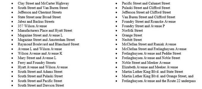
Roads closed in Newark due to flooding

Drivers in Newark are asked to avoid the following locations due to the potential for flooding:

Jul 18, 2026, 7:27 PM GMT

Tornado watch issued until 9 p.m.

A Tornado Watch has been posted for parts of the area until 9 p.m. ET. Widespread damaging wind gusts up to 70 mph, and a few tornadoes are possible within the watch area in the coming hours.

Severe Thunderstorm Watches have been posted for a large area, stretching from eastern Illinois to upstate NY down into the mid-Atlantic. Strong, potentially damaging wind gusts are the primary concern for these locations.

The flash flood threat continues across several states as well with Flood Watches from DC to Philly to NYC.

Rounds of heavy rain and thunderstorms will continue to sweep across these regions through the afternoon and evening hours.

Jul 18, 2026, 7:27 PM GMT

Unhealthy smoke returns ahead of powerful storms

Smoke from Canadian wildfires has once again blanketed New York City and the Tri-State, creating unhealthy air quality across much of the region Saturday morning as an AccuWeather Alert remains in effect.

Air quality reached an AQI of 173 early Saturday, a level considered unhealthy for everyone - not just people with asthma or other respiratory conditions. Thick smoke and haze reduced visibility across the area, with conditions expected to worsen through the morning before gradually improving later in the day.

Shifting winds will continue to push smoke across the region through midday, with air quality deteriorating in parts of Long Island and northern suburbs before the smoke begins to thin out. Residents are encouraged to limit prolonged time outdoors, avoid strenuous activities like running or exercising outside, and keep windows closed if possible.

The improvement in air quality, however, comes with a tradeoff.

Strong to severe thunderstorms are expected to develop later Saturday afternoon and continue through the evening as a cold front moves through the region. Storms could bring flooding downpours, damaging wind gusts and a few isolated tornadoes, prompting forecasters to urge residents to stay weather-aware. New Jersey, New York City and southern Westchester are under a flood watch ahead of the storms.

The first scattered showers are expected to develop during the afternoon, with the greatest risk for severe weather between about 4 p.m. and 9 p.m. The threat could linger until around midnight before the front clears the area.