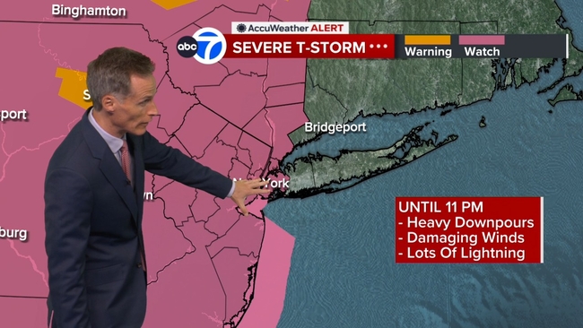
AccuWeather Alert: Severe thunderstorm warnings, watches issued
AccuWeather forecast for NYC, New York, New Jersey and Connecticut


NEW YORK (WABC) -- We will be keeping a close eye on the radar through the evening, with a Level 2 out of 5 risk of severe weather in place across the area.
Severe Thunderstorm watches have been issued for New York City and most of the Tri-State, while warnings have been issued for portions of the region, including Long Island, and parts of New Jersey.
Click here for the latest advisories, watches and warnings from the National Weather Service
The primary threats are damaging winds and heavy downpours, raising concerns about a repeat of the storm damage that affected parts of New Jersey Friday night.
The Macy's Fourth of July Fireworks show start time was moved up to 9:02 p.m. due to the storm threat, giving the celebration a narrow window to avoid the impacts of the storm.
By around 9:30 p.m., large thunderstorms were positioned both north and west of the city, and are expected to gradually spread across New York City and Long Island later in the evening.
Relief from the heat arrives on Sunday as much cooler air moves into the region. High temperatures are expected to reach only the lower 80s, aided by easterly winds flowing in from the cooler waters of the Atlantic Ocean. While an afternoon shower or thunderstorm is possible, the greatest chance will be west of New York City.
The weather pattern turns more unsettled Sunday night as showers and thunderstorms redevelop across the area. While severe weather is not expected, forecasters are concerned about the potential for heavy rain. Rainfall totals of 2 to 3 inches are possible in some locations from late Sunday through Monday, which could lead to localized flooding despite ongoing drought conditions across much of the region. Wet weather may persist through Monday night and even into early Tuesday before conditions begin to improve.
The unsettled pattern lingers into Tuesday with clouds, humidity, and a chance of showers, while temperatures remain unusually cool in the mid-70s. After that, the weather improves. Wednesday will bring breaks of sunshine and temperatures around 82 degrees before readings climb back into the upper 80s later in the week. While temperatures will not approach the extreme heat experienced recently, humidity will increase, and another chance of thunderstorms may return by Friday into Saturday.
LATEST ACCUWEATHER FORECAST
THE 7-DAY FORECAST
Sunday
Not as hot, PM storm. High 84
Monday
Soaking storms. High 73
Tuesday
Humid, still a shower. High 75
Wednesday
Nice and normal. High 82
Thursday
Partly sunny and very warm. High 88
Friday
Warm and humid. High 87
Saturday
Humid, sun at times. High 85

Follow the Weather or Not podcast with Lee Goldberg
Please fill out the form below to submit weather photos and videos.
MORE ACCUWEATHER RESOURCES
Check AccuTrack Radar
Air Quality Tracker
NWS Advisories, Watches and Warnings
School closings and delays
For weather updates wherever you go, please download the AccuWeather app.
Follow chief meteorologist Lee Goldberg, Sam Champion, meteorologist Brittany Bell, meteorologist Jeff Smith, and meteorologist Dani Beckstrom on social media.