NYC climate plan aims to prevent what could be daily flooding in Lower Manhattan

LOWER MANHATTAN, New York City (WABC) -- It's no secret that we need to act now in order to combat climate change, and the New York City Economic Development Corporation and mayor's office are working together to do just that.
Lower Manhattan is on track to flood monthly in less than 20 years, and 60 years from now, that part of the island could be flooding daily.
And by 2100, daily high tides could flood most of the area east of Water Street, according to the NYDEC.
WATCH | Weather or Not: How you can fight climate change

So what's the plan to protect Lower Manhattan?
"The cost of inaction are quite severe and would be tens of billions of damages that we would expect to accumulate over the coming decade," said Elijah Hutchinson, vice president of neighborhood strategies with the New York City Economic Development Corporation.
The city is creating a plan to protect the financial district and seaport neighborhoods from coastal flooding.
It is all a part of a larger plan, the Lower Manhattan Coastal Resiliency Strategy.
The main flood threats for Lower Manhattan are daily tidal flooding, coastal storms, and extreme precipitation.
"We are expecting, in terms of climate impact, the potential for there to be flooding over the edge of the seaport waterfront by the 2040s," Hutchinson said. "And it's really important that we act now."
ALSO READ | Coastal resiliency projects underway around city to protect vulnerable neighborhoods from flooding

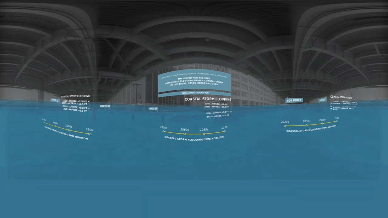
Projections show what daily high tide flooding could look like in 2080 underneath the FDR Drive between South Street and Pier 11, and the goal is to mitigate that risk by elevating natural landscape and installing flood gates and walls.
Two virtual public meetings were hosted to share the draft project design, showing images of what the new seaport could look like.
"People are really excited about having a new waterfront that they can really enjoy," Hutchinson said. "And also benefit from flood protection."
The draft images were presented at the public meetings, and the NYDEC plans on issuing their final design by the end of the year.
----------
* Get Eyewitness News Delivered
* More New York City news
* Send us a news tip
* Download the abc7NY app for breaking news alerts
* Follow us on YouTube
Submit a News Tip