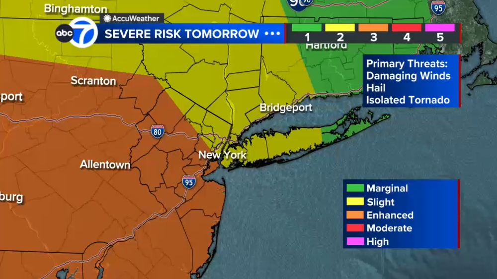
Winter Storm Updates: Tri-State copes with damage, severe flooding in parts

NEW YORK (WABC) -- A powerful winter storm spawned flooding and rescues in New Jersey and caused downed trees and powerlines in some parts of New York.
In NYC, nearly 2 inches of rain (1.95 inches in Central Park) fell overnight into Wednesday, causing widespread flooding of poor drainage and low-lying areas. Most, if not all of that flooding had dissipated by Thursday morning.
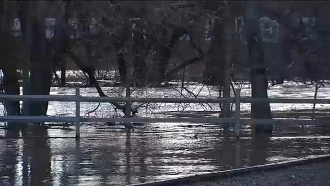
In New Jersey, where Gov. Phil Murphy declared a state of emergency in advance of the storm, eyes are still on the Passaic and Ramapo Rivers which have not crested as of Thursday morning. The Saddle Brook River crested on Wednesday and caused widespread flooding throughout Lodi.
Nearby Caldwell, New Jersey, got 3.22 inches of rain.
Some 5,000 customers in New Jersey remained without power Thursday morning.
Latest AccuWeather Forecast
Check river levels in New Jersey
School closings and delays in New York, New Jersey, and Connecticut
Send your weather photos to Eyewitness News
Latest AccuTrack Radar
STORM UPDATES
Evacuation orders in Norwich, CT lifted
Evacuation orders have been lifted in Norwich, CT, where a dam sprung a leak during the winter storm.
Sandbags have been put in place so that workers can make repairs.
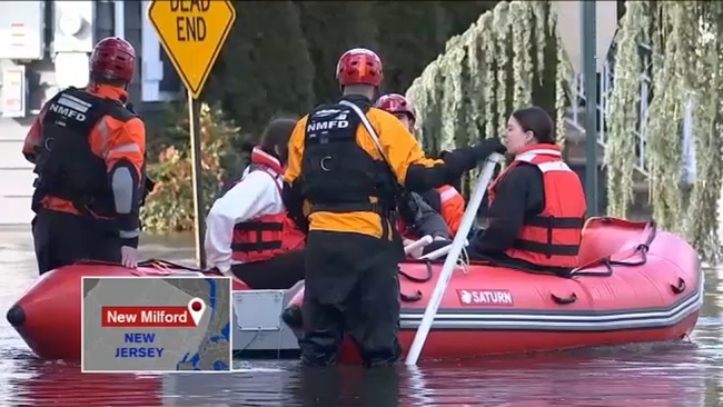
Dozens rescued in New Milford
Dozens of people were rescued from flooded homes in New Jersey and some rivers haven't even crested yet.

In New Milford, first responders know the drill as flooding has been an ongoing issue when storms and high tides meet.
Mayor Michael Putrino says the town has been in talks with state officials about trying to address the flooding issues once and for all.
Toni Yates had details from New Milford.
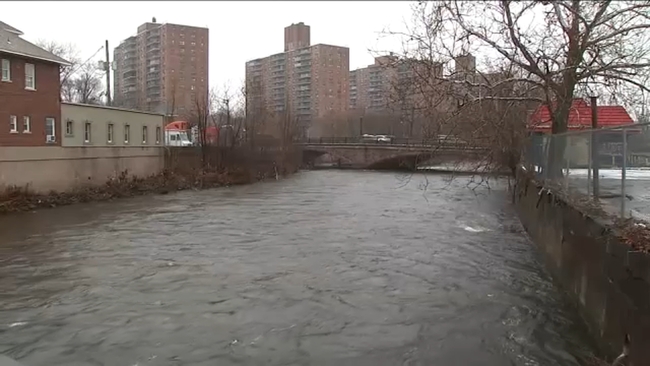
Passaic River flood levels could exceed height from December storm: officials
The Fairfield Police Department projected the Passaic River to rise to 21.9 feet by Thursday morning.
Residents nearby are urged to evacuate as the river is expected to crest sometime Thursday.
In addition to Gov. Murphy's State of Emergency, Paterson Gov. Andre Sayegh announced a State of Emergency Monday for the city.
The governor was criticized for his failure to declare a state of emergency in advance of last month's storm. State officials say his decision to do so on Monday underlined how much worse Tuesday's rainfall could be.
It was late December, just days before Christmas, when the river over-spilled its banks from a deluge of rain.
It reached major flood stage at 21.5 feet and caused homes to flood and some residents needed high water rescues.
"We had to perform rescue operations from our previous storm a few weeks ago, we have high water vehicles prepared as well in the event we have to rescue resident," Paterson Mayor Andre Sayegh said.
The Passaic River will start flooding once it reaches 19 feet and officials are expecting it to swell beyond that level again.
"Real prep would be at this point, I know a lot of these people who were impacted the first time just finished restoring. Their homes just had hot water and heat and furnaces replaced in their homes, doing anything you can to mitigate any potential loss of those in the second round," Mayor of Little Falls James Belford Damiano said.
Phil Taitt reports on Thursday's Passaic River levels.
Wayne Public Schools delayed opening
Wayne Township Public Schools announced a 90-minute delayed opening on Thursday, due to expected flooding and hazardous road conditions.
Residents can check the public school's official website for more details.
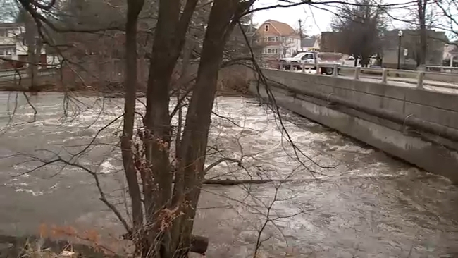
Watching the Saddle River in Lodi
In Lodi, the Saddle River was cresting higher than expected Wednesday. The river's levels were up to 10 inches.
Lodi Public Schools closed Wednesday due to the flooding and road closures.
Eyewitness News Reporter Darla Miles reported from Lodi on the conditions.
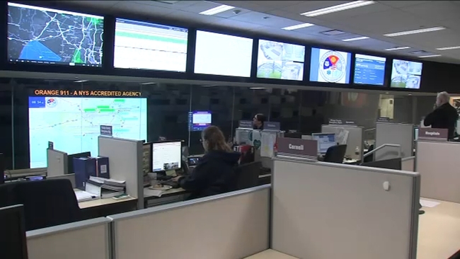
Orange County OEM response to flooding
There were rescues performed overnight in parts of Orange County.
Rescuers responded to a driver trapped in a submerged vehicle on Palisades Parkway.
In the southeastern part of the county there were water rescues between 11 p.m. and 2 am., with a lot of people in stranded cars trying to drive through water.
Eyewitness News Reporter Janice Yu spoke with the head of the Office of Emergency Management in the county about the overnight efforts.
Retaining wall collapse in Bronx
A retaining wall has collapsed on top of an auto body shop in the Bronx.
Officials say the wall that supports about 10 homes fell at around 7 a.m. Wednesday on Anthony and Carter avenues.
Neighbors say they previously went to the city for help, but the city argued the retaining wall was their responsibility.
Aftermath on Long Island
As high tide neared closer on Long Island on Wednesday morning, parts of the southern shore were already inundated by coastal flooding.
In Nassau County, video showed cars sloshing through water that had collected on the streets of Freeport. The mayor of Freeport detailed their efforts.
Chantee Lans was in Freeport.
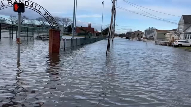
Further east, near the Hamptons, the National Weather Service reported major flooding out of Shinnecock Bay.
Several schools across Long Island said they were either canceling or delaying classes as a result of the storm.
Suffolk County State of Emergency
Suffolk County Executive Ed Romaine issued a state of emergency Tuesday morning ahead of the storm.
"I am issuing a State of Emergency for Suffolk County to ensure our residents are best prepared for the incoming severe weather," said Romaine. "While the height of the storm is anticipated to impact the County during the evening and overnight hours, I strongly advise our residents to avoid travel as heavy rainfall, strong wind gusts and potential flooding are all possible."
Coastal flooding is possible along the county's shorelines as widespread moderate floods in usual areas are projected in conjunction with the Wednesday morning high tide cycle. In addition, flash flooding may be possible in poor drainage areas. The county is also under a high wind warning.
Long Island power
PSE&G Long Island says power has been restored to more than 99.5% of customers that were impacted by the gusty winds and heavy rain that brought down trees and heavy branches onto wires, causing scattered power outages.
As of 8:15 p.m., PSE&G Long Island said they restored power to more than 26,400 customers. They are reporting that 124 of its 1.2 million customers are currently without service.
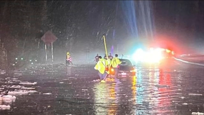
Rock slide concerns and road closures
In Rockland County, the Palisades Interstate Parkway is closed by flooding and debris on the roadway.
Further north, Route 6 at the parkway was also closed after vehicles were reportedly submerged in water, with people rescued.
Rescues were also reported in Highland Falls and also in Orange County. Those locations had similar flooding last July, and are still recovering.
Janice Yu reports from Stony Brook on Wednesday's road conditions.
Orange County fatal crash
One person was killed in a crash on I-87 in Woodbury just after 12 a.m. Wednesday. A preliminary investigation found that a tractor trailer fatally struck a man who was standing outside of a Volvo vehicle stopped on the right shoulder of the roadway.
The victim was identified as 42-year-old Jose Payano of Plainfield, New Jersey.
The driver of the tractor trailer was taken to a nearby hospital with non-life-threatening injuries. He was ticketed as a result of the crash.
Eyewitness News reporter Anthony Carlo was in Orange County with more.
Transit updates
After disruptions to both LIRR and Metro-North service on Wednesday morning, by 3:30 p.m., the MTA said all issues were resolved after the storm.

Storms lead to delays and flight cancellations at all local airports
As of Wednesday morning,
- LaGuardia had canceled 45 flights, 8% of its flights
- JFK Airport canceled 20 flights, 3% of its flights
- Newark canceled 39 flights, 6% of its flights
Check your flight status by visiting the appropriate airport website:
Newark Liberty International Airport
John F. Kennedy International Airport
LaGuardia Airport
Orange and Rockland Utilities mobilize emergency response team
Orange and Rockland Utilities mobilized its emergency response workforce Tuesday night to repair potential damage and restore possible power outages that could result from strong gusty winds, heavy rainfall and localized, inland flooding throughout the region until 4 a.m. Wednesday.
NYC Ferry service impacted
Due to high winds, NYC Ferry service on the St. George route, between Manhattan and Staten Island, and Rockaway was suspended. Customers were asked to consider alternate routes. You can find the latest updates here.
Hoboken builds up barriers to ease flooding
Hoboken sits below sea level, and ever since Superstorm Sandy, the city has been building up its barriers to prevent and ease flooding.
In the last 8 months, Hoboken has installed barriers along pockets where they know flooding can be an issue.
"We've made a lot of investment in our pumps, our infrastructure, and we are confident they will hold up, but anytime we see this much rain over a short period of time, it is concerning," said Hoboken business administrator Jason Freeman.
Toni Yates had more from Hoboken:
South Brunswick fallen tree
A fallen tree on Pinter Lane in South Brunswick, New Jersey, blocked the road and knocked down power lines, leaving about 15 homes without power.

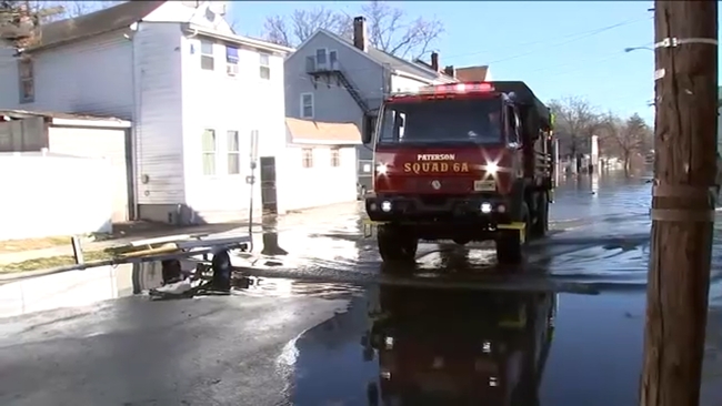
Paterson temporary shelters
Temporary shelters opened in Paterson, New Jersey as Passaic County braced for massive flooding.
Troy Ayers of the Paterson Office of Emergency Management said they are going to go around early and ask everybody to leave their homes that they know are in flood-prone areas.
One such temporary shelter will be at 60 Temple St.
CeFaan Kim had more from Paterson:
MTA to ban empty tractor-trailers and tandem trucks
MTA Bridges and Tunnels temporarily banned empty tractor-trailers and tandem trucks Tuesday as the agency prepares for high winds and heavy rains.
"High winds are always a particular concern for long-span bridges," said MTA Bridges & Tunnels President Catherine Sheridan. "MTA Bridges and Tunnels' personnel will closely monitor the weather conditions and wind speeds and are ready to respond immediately to any issues which occur."
Pedestrian walkways at the Cross Bay Bridge and Marine Parkway Bridge were closed during this time. Pedestrian walkways at the Robert F. Kennedy Bridge and the Henry Hudson Bridge remained open as weather conditions permitted.
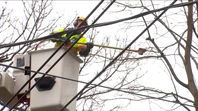
How Con Ed got ready for the storm
The threat of high wind from the storm could mean downed trees and power lines, leading to power outages.
Con Ed is preparing crews to respond to any outages and even proactively trimming trees on Tuesday to mitigate any potential damage.
Marcus Solis has more from Mamaroneck:
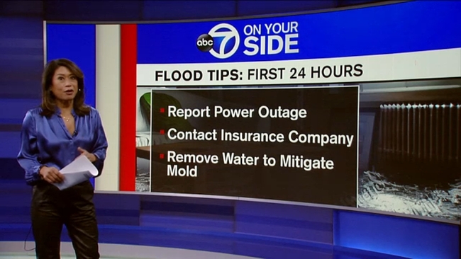
7 On Your Side's tips on what to do if your home or car floods
We have seen a lot of flooding recently, so how can you make sure you are protected if this upcoming storm impacts you?
7 On Your Side's Nina Pineda has some tips:
Early dismissals for some schools
Check for the latest school closings, delays and early dismissals.
Newark traffic advisory
Officials in Newark announced locations around the city that should be avoided Tuesday night into Wednesday due to the potential for flooding:

Paterson State of Emergency
Paterson Mayor Andre Sayegh declared a State of Emergency that will go into effect at 5 p.m. on Tuesday.
His main message during a press conference Tuesday morning was that New Jersey is preparing an effective response to the conditions expected to impact the region. He said officials are preparing for the worst but hoping for the best.
ALSO WATCH | Dangerous winter storm to unleash floods, winds: Weather or Not

State of Emergency in New Jersey
Governor Phil Murphy declared that New Jersey entered a State of Emergency at 5:00 p.m. on Tuesday in anticipation of hazardous weather conditions including heavy rain, high winds, and flash flooding.

The State of Emergency across all 21 counties in New Jersey allowed resources to be deployed throughout the state during the duration of the storm.
"Beginning (Tuesday) morning and continuing through Wednesday morning, we are expecting one to four inches of heavy rain, strong winds, and potential inland and coastal flooding," said Governor Murphy. "This storm will exacerbate the effects of the inclement conditions we experienced in December and this past weekend and may precede another storm Friday night. As always, I urge all New Jerseyans - including residents in our coastal and riverine communities - to follow all safety protocols and remain off the roads unless absolutely necessary."
The Governor encouraged New Jerseyans to visit ready.nj.gov for important weather updates and safety information. Residents should also monitor local forecasts, warnings, and watches.
Hochul urges New Yorkers to be prepared
During an afternoon news conference, New York Governor Kathy Hochul said state officials were closely monitoring forecasts and preparing for every possible outcome.
"Now make no mistake, this could be a life-threatening storm. It is a statewide event, but it's hitting the different regions of our state very differently," she said.
With flash flooding a major concern, the state was pre-deploying four SWIFT water rescue teams from state agencies.
"The DOT and Thruway Authority are proactively checking and clearing storm drains and culverts," Hochul said.
Digital billboards were being used to warn drivers as well.
Hochul said the state was prepositioning over 8,800 utility workers and 75 massive generators to be able to handle any power outages that impact traffic signals.
The New York City Emergency Management Department issues a Travel Advisory
New York City issued a travel advisory for Tuesday evening into Wednesday.
"Our city government is prepared to respond to whatever comes our way, but residents should also take the necessary precautions to stay safe and protect their belongings. I encourage all New Yorkers to sign up for Notify NYC to get the latest information and closely monitor the forecast as this storm approaches," said New York City Mayor Eric Adams.
New York City Emergency Management, in response to the forecasted weather, activated the city's Flash Flood Emergency Plan, and coordinated calls with the National Weather Service, partner agencies, as well as utility companies to ensure a unified and coordinated response.
New York City Department of Environmental Protection (DEP) crews checked flood-prone locations to ensure the functionality of catch basins and drainage infrastructure. DEP also prepared to manage stormwater with cleaned and inspected Bluebelts and monitor flooding on arterial highways.
The New York City Department of Transportation (DOT) monitored road conditions at its Traffic Management Center and coordinate with sister agencies for flood conditions, while also assisting in clearing catch basins to prevent roadway flooding.
MTA prepares for weather-related issues
NYC subway
Due to the nature of the subway system, rainwater will inevitably go down into the system and impact infrastructure. NYC Transit's focus during heavy rain events is to minimize impacts to service by responding and removing water quickly when it does infiltrate the system.
Metro-North
Metro-North's crews will be poised to protect the system against the effects of the rain, wind and snow melt expected on Tuesday evening and Wednesday morning and will be especially focused on the northern portions of its territory, which in some areas received up to a foot of snow over the weekend.
Long Island Rail Road
"LIRR crews are preparing the system for the incoming weather by pre-positioning equipment so they can respond quickly to any challenges brought on by the heavy winds and rain," said Acting LIRR President Rob Free. "This storm is expected to affect the ride home on Tuesday and the ride to work on Wednesday and customers should monitor the TrainTime app and the MTA Web site for real time service updates."
Hochul urges New Yorkers to prepare
Governor Kathy Hochul is urging New Yorkers to prepare as the storm system with heavy rain and very strong winds, will likely cause flooding and power outages throughout the state beginning Tuesday and lasting through Wednesday.
The system is expected to produce wind gusts of 50-60 mph across New York City, Long Island, Western New York, Central New York and the North Country, with gusts of 70 mph possible along the shores of Lake Erie and Lake Ontario. The North Country may also see up to a foot of snow, especially in higher elevations.
"After the weekend weather brought snow across our State, a new storm threatens to cause substantial flooding and gale force winds - posing a risk of power outages and creating unsafe travel conditions," Governor Hochul said. "I have directed State agencies to monitor the storm closely as it unfolds, and they are prepared to work with our local partners as needed. I ask all New Yorkers to please take caution and keep track of weather and travel information in your area."
In the city, NYC Emergency Management has issued a travel advisory for the storm.
A Flood Watch is in effect citywide ahead of the storm for Tuesday evening through Wednesday afternoon. A High Wind Warning and Coastal Flood Warning will also go into effect for parts of the city.
"More inclement weather is expected to hit New York City tomorrow night, bringing with it heavy rains, strong winds, and the potential for flooding," New York City Mayor Eric Adams said.
PSE&G prepared for rain and wind
In advance of the storm, PSE&G crews are performing system and logistics checks to ensure the availability of critical materials, fuel and other supplies to bring customers safe and reliable service regardless of extreme weather conditions.
"PSE&G is closely monitoring this latest weather front and we are once again prepared for potential impacts on the system," said John Latka, senior vice president, PSE&G Electric Operations, Transmission & Distribution. "We have crews scheduled 24/7 who will be ready for restoration once weather conditions permit. Our crews will work to safely restore any outages as quickly as conditions will allow."
(The Associated Press contributed to this report.)
NWS Advisories, Watches and Warnings
For weather updates wherever you go, please download the AccuWeather app.
Follow meteorologist Lee Goldberg, Sam Champion, Brittany Bell, Jeff Smith, and Dani Beckstrom on social media.
----------
* Sign up for free newsletters
* Download the abc7NY app for breaking news alerts
Submit Weather Photos and Videos
Have weather photos or videos to share? Send to Eyewitness News using this form. Terms of use apply.